Learn More
Remuera
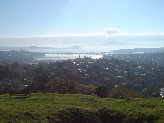
Remuera is an affluent inner city residential suburban area within Auckland, in the North Island of New Zealand.It is located four kilometres to the southeast of the city centre. Remuera is one of Auckland’s older suburbs characterised by many large houses, often Edwardian or mid 20th century. A prime example of a “leafy” suburb, Remuera is noted for its quiet tree lined streets. The suburb has numerous green spaces, most obvious of which is Ōhinerau / Mount Hobson – a volcanic cone with views from the top overlooking Waitematā Harbour and Rangitoto.
According to the 2013 census, Remuera has a population of 7,254 people. The suburb extends from Hobson Bay and the Orakei Basin on the Waitematā Harbour to the north and east, to the main thoroughfare of State Highway 1 in the southwest. It is surrounded by the suburbs of Orākei, Meadowbank, Saint Johns, Mount Wellington, Ellerslie, Greenlane, Epsom, Newmarket and Parnell. Remuera is home to many well-known New Zealanders including the late Sir Edmund Hillary and the famous race car driver Bruce McLaren.
Remuera includes some interesting nature areas and parks. Unlike the rest of the isthmus of Auckland, which was largely void of large trees and covered with native grass, flax and manuka, Remuera retained patches of native bush and woodland. This was remarked on by Dr John Logan Campbell who waxes lyrical about the Remuera forest trees and the songs of the native birds: “Beautiful was Remuera’s shore, sloping gently to Waitemata’s sunlit waters in the days of which I write. The palm fern-tree was there with its crown of graceful bending fronds and black feathery- looking young shoots; and the karaka, with its brilliantly-polished green leaves and golden-yellow fruit, contrasting with the darker crimped and varnished leaf of the puriri, with its bright cherrylike berry. Evergreen shrubs grew on all sides, of every shade from palest to deepest green; lovely flowering creepers mounted high overhead, leaping from tree to tree and hanging in rich festoons; of beautiful ferns there was a profusion underfoot. The tui, with his grand rich note made the wood musical; the great fat stupid pigeon cooed down upon you almost within reach, nor took the trouble to fly away.” “Poenamo.”
The Orākei Basin, a tidal lagoon popular for water sport activities, is the submerged crater of a volcano. There is a 3 km public walkway around the basin whereby the flora and fauna of the area can be observed at close hand.
Mount Hobson Domain includes the volcanic cone, previously used as a pā (a defended settlement) by the Māori and in later times as a quarry and pasture land. Ōhinerau / Mount Hobson (143m high) is one of Auckland’s better preserved and least modified volcanic cones. Formed some 25,000 years ago, the volcanic hill has a horse-shoe shaped crater opening to the southwest. Terraces and pits are still evident from the Maori occupation. Like the other volcanic hills of the Auckland isthmus, in the 20th century, water reservoirs were built on the summit and the lower southwest side a water reservoir was incorporated into Ōhinerau / Mount Hobson to supply water to the surrounding area. Still evident on the south-east side of the mountain is the concrete base remnant of a WWII medical store for the US Navy Mobile Hospital in nearby Market Rd – a site now occupied by the Dilworth Junior School. As you walk up the path from the entrance, you will soon come to a stone seat – a memorial to Remuera boys who died in WWII. This overlooks a field of jonquils and daffodils which bloom in winter or early spring.